
![]()
![]()
![]()
![]()
![]()
![]()
![]()
![]()
![]()
![]()
Digital Orthophotography
 Digital
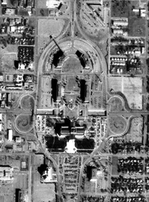
Orthophotos (DOQQs) combine the image characteristics of a photograph
with the geometric qualities of a map. Unlike a standard aerial photograph,
relief displacement in orthophotos has been removed so that ground features
are displayed in their true ground position. This allows for the direct
measurement of distance, areas, angles, and positions. Also, an orthophoto
displays features that may be omitted or generalized on maps.
Digital
Orthophotos (DOQQs) combine the image characteristics of a photograph
with the geometric qualities of a map. Unlike a standard aerial photograph,
relief displacement in orthophotos has been removed so that ground features
are displayed in their true ground position. This allows for the direct
measurement of distance, areas, angles, and positions. Also, an orthophoto
displays features that may be omitted or generalized on maps.
They serve a variety of purposes, from interim maps to field references for earth science investigations and analyses. The digital orthophoto is useful as a layer of a geographic information system and as a tool for revision of digital line graphs and topographic maps.
The State of Oklahoma currently has statewide digital orthophotos for the years 2003-2006, 2008, 2010, 2013, 2015, 2017, 2019 and 2021. The 2003, 2008, 2010, 2013, 2015 and 2017 orthophotos have a resolution of 1 meter while the 2004-2006 orthos are 2 meter. The 2019 orthophotos are available at a 0.5 meter resolution. The most current 2021 orthophotos have a resolution of 0.6 meter. All images have been flown leaf on and are compressed using Mr. Sid into one file per county. The files can be downloaded from the Council's ftp site:
For Internet Explorer use the following link:
ftp://okmaps.org/okmapsftp
user name: okmapsftp
password: spamk077
For Firefox and Chrome use the following link:
ftp://okmaps.org/
user name: okmapsftp
password: spamk077